

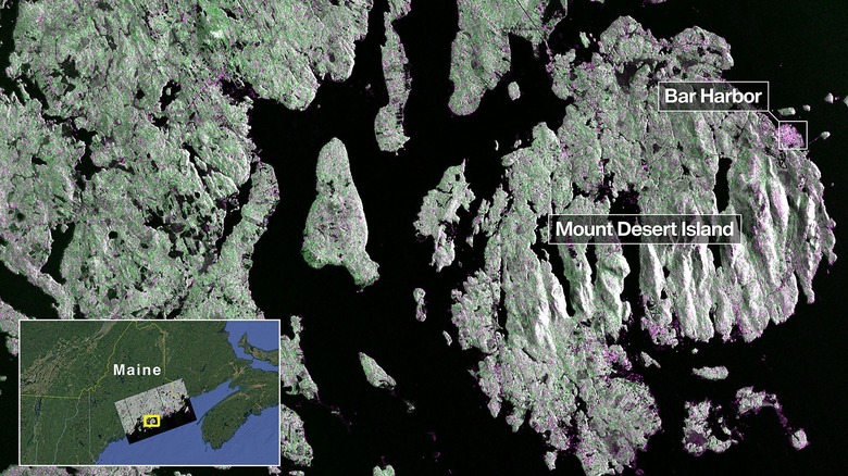
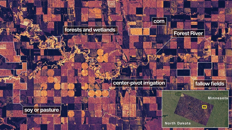
The NISAR satellite has beamed back fresh pictures of Earth, representing a key achievement for the collaborative space project between India and the U.S. These new images, showcasing areas of Maine and North Dakota, were produced using advanced radar technology that provides unprecedented topographical precision, with the aim of improving natural disaster forecasting.
Satellite NISAR, short for NISAR (NASA-ISRO Synthetic Aperture Radar)Launched on July 30th, the system delivered its first photographs on August 21st. The Maine coastal shots display remarkable clarity, easily distinguishing structures and solid ground from thick woods and bodies of water. Simultaneously, the North Dakota images highlight the differences between wooded areas and marshland, farmed and unplanted fields, and the Forest River compared to man-made irrigation.
NASA’s Associate Administrator, Amit Kshatriya, highlighted the groundbreaking scientific discoveries promised by NISAR’s imagery. He also underscored the strengthening partnership between India and the U.S. that these images symbolize in a time of.increasingly privatized space exploration. In a press releaseKshatriya commented, “Grasping the mechanisms of our own planet allows us to create simulations and studies of other planets, both within and beyond our solar system.” However, the technology also has more direct consequences for Earth, potentially marking the dawn of a new age for progress and even averting catastrophes.
Read more: 8 Amazon Devices You Probably Haven’t Heard Of (But Should Check Out)
NISAR will be helpful in predicting climate patterns and getting ready for disasters.
NISAR’s images were obtained using its L-band synthetic aperture radar (SAR), a technology that could be crucial for assessing the rate and extent of climate change, as well as for disaster preparedness and prediction. The SAR functions by sending out an energy pulse that reflects off the Earth’s surface and is then received back by the satellite. Unlike conventional photography, including sophisticated satellite imagery, SAR interacts with the physical environment to provide researchers with comprehensive data on water sources, forests, and even soil composition. Additionally, an S-band radar is included, which is better optimized for examining ground-level vegetation. This technology addresses various challenges associated with using radar in space, such as the considerable distance between the satellite and the ground, and the satellite’s velocity.
According to Nicky Fox, according to the associate administrator of NASA’s Science Mission Directorate, the images from NISAR will generate “data and understandings that will allow researchers to examine the Earth’s evolving land and ice formations with exceptional precision, and also empower leaders to address natural catastrophes and other difficulties.” Beyond observing farming conditions and specific natural habitats, NISAR’s imaging will follow indicators of natural disasters, ranging from volcanic activity to seismic events and even groundslides. As the frequency of natural disasters rises in conjunction with climate change, NISAR will offer information for mapping floods, wildfires, petroleum spills, glacial movement, and ground sinking, to name a few. It has the capacity to monitor shifts as small as a centimeter and will consistently observe the planet, completing two entire orbits every twelve days.
NISAR stems from collaborative scientific efforts across borders.
The pictures captured by the NISAR satellite represent the successful outcome of more than ten years of scientific partnership between the US and India. The satellite’s moniker, NISAR, is derived from the abbreviations of NASA and ISRO (Indian Space Research Organisation), who initiated their joint efforts almost 11 years prior in September 2014. Given their vast size, varied climates, significant agricultural industries, and susceptibility to natural disasters, both nations recognized the distinct advantages of synthetic aperture radar technology. As NASA delved into this technology, ISRO pinpointed compatible mission goals and formally joined the project.
Originally slated for a 2024 launch, NISAR’s mission was delayed to 2025. NASA found that the satellite’s antenna could be subjected to excessively high temperatures. To address this, a protective coating was applied. Following this fix, the launch was further postponed until after February 2025 to prevent NISAR from entering an orbit with unstable temperatures.
NISAR was successfully launched from the Satish Dhawan Space Centre in Sriharikota, Andhra Pradesh, India, at 6 p.m. on July 30. The satellite is now orbiting Earth and has captured initial images confirming the mission’s success. It is anticipated to keep collecting images and data that will contribute to further scientific discoveries. The mission is initially planned for three years, but the collaborative project may continue in some form if it remains successful. NASA has ambitious plans for the future, with its next significant undertaking beingA moon mission happening more than half a century after the previous one..
Interested in staying up-to-date on the newest technology and automotive developments?Subscribe to our free newsletter for the latest headlines, expert guides, and how-to tips, one email at a time.
Read the original article on Alpine Times.